How Interstate Highway System origins changed U.S. cities
The phrase Interstate Highway System origins signals more than a legislative birthdate. It marks the moment American mobility, real estate, and civic life were rewired at national scale. To see why infrastructure shapes behavior, recall how clean air functioned as a hidden network in the Great London Smog, or how reconstruction principles guided urban planning after the Lisbon earthquake of 1755. In both stories, design decisions altered daily choices. The Interstate took that logic, multiplied it across states, and folded it into defense and growth.
Historical Context
From early road policy to Cold War urgency
Before the 1950s, American roads were patchwork. The 1916 and 1921 Federal Aid Road Acts nudged states to coordinate, but funding and standards varied widely. Rail still moved goods reliably. The car spread faster than policy could adapt. By the late 1930s, engineers sketched “interregional” corridors, imagining safer, straighter lanes bypassing crowded town centers.
World War II changed the stakes. Military logistics demanded continuous routes that heavy vehicles could trust in any weather. After the war, suburban homebuilding surged while defense planners pushed for evacuation and deployment paths. The 1956 Federal-Aid Highway Act codified the national grid, promising a vast limited-access network. In popular memory, the idea seemed obvious. Yet the Interstate Highway System origins were a negotiated blend of engineering ambition, federalism, and security doctrine.
Blueprints, budgets, and federal–state math
The program targeted roughly 41,000 miles of limited-access roads. The funding model was simple and potent: the federal government would cover 90 percent, leaving states 10 percent to match. That formula aligned incentives, easing coordination across jurisdictions. It also placed Washington at the center of route selection, standards, and approval. The Interstate Highway System origins thus fused national priorities with local maps—an arrangement that made the network coherent yet often controversial on the ground.
Key Facts and Eyewitness Sources
What the build-out actually did
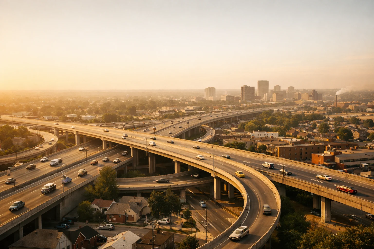
Construction budgets were enormous in 1950s dollars, and the timelines stretched across decades. Crews cut new corridors, straightened alignments, and built interchanges that reoriented regional travel. Downtown trucking access improved even as through-traffic was diverted to ring roads. Commuters gained speed at rush hour—at least initially—while freight carriers synchronized schedules over long distances. The Interstate Highway System origins created a common design language: lane widths, shoulders, medians, and signage standardized driver experience from coast to coast.
On city blocks, however, residents witnessed a different story. Right-of-way acquisition razed houses and businesses. Street grids were severed. Neighborhoods closest to proposed alignments—often politically weak or redlined—absorbed the worst disruptions. Local newspapers recorded both excitement for smooth new roads and grief for uprooted communities. Planners talked about “blight clearance,” while shop owners counted the cost of lost foot traffic. The Interstate Highway System origins were celebrated in ribbon cuttings and protested in community meetings.
Memory, testimony, and postwar expectations
Eyewitness accounts capture the paradox. Some families gained suburban access to jobs and schools. Others watched noise walls rise where porches once faced quiet streets. City leaders bet on big parking garages and wider arterials, assuming that cars would anchor future prosperity. Activists argued that streets should also serve children, small merchants, and walkers. These testimonies teach a central fact: design encodes values. The Interstate Highway System origins embedded a mobility first principle that cities have been renegotiating ever since.
Analysis / Implications
Induced demand, land values, and regional footprints
Once lanes appear, people use them. Economists call it induced demand: driving increases with capacity, reshaping trip timing and destination choices. Over time, more lanes can mean more traffic rather than permanent relief. A landmark study formalized this pattern, showing vehicle miles traveled scaling with roadway provision. The insight reframes congestion as a system property, not a temporary glitch in need of more concrete. The Interstate Highway System origins thus launched a feedback loop among travel behavior, development patterns, and fiscal choices.
The network also shifted land values. Easy access favored edge-of-city sites for warehouses, malls, and office parks. Downtown parcels rose or fell depending on whether ramps brought shoppers or bypassed main streets. Tax bases moved with rooftops and jobs. Air quality and noise burdens clustered near interchanges. These distributional effects underlie today’s debates over cap parks, teardown proposals, and congestion pricing—tools that attempt to rebalance costs and benefits baked in at the start.
Security, commerce, and the logistics flywheel
Defense planners wanted rapid mobilization; shippers wanted predictable schedules. Interstates delivered both. Crucially, reliability—fewer stops, consistent speeds—lowered inventory costs across supply chains. Seaports, rail yards, and airports knitted to highway spines, accelerating just-in-time production and next-day delivery. Here the network’s power mirrors older systems explored in studies of imperial roads and courier lines. On the civic side, the same design that sped trucks often sliced neighborhoods, raising the question of how to retrofit corridors without losing freight performance.
For official milestones and design standards, see the U.S. Federal Highway Administration’s overview. For induced demand evidence, consult the foundational research formalizing the mechanism. These two sources frame the technical baseline behind the social story.
External sources: Federal Highway Administration – Interstate overview; NBER – The Fundamental Law of Road Congestion
Case Studies and Key Examples
Corridors that divided—and the movements they sparked
In several cities, interstate alignments paralleled older “urban renewal” targets. The Cross Bronx Expressway carved deep cuts through dense neighborhoods, accelerating population loss on adjacent blocks. In New Orleans, Claiborne Avenue’s live-oak median gave way to elevated lanes; community markets faded in the shadows. St. Paul’s Rondo district, split by I-94, later became a symbol for restorative design. Syracuse’s I-81 viaduct motivated a long campaign for a street-level boulevard. Each case shows how the Interstate Highway System origins intersected with local power, shaping which places received protection and which absorbed sacrifice.
Activism followed. Church basements hosted organizing sessions; lawyers challenged route decisions; architects mapped alternatives. Some efforts rerouted segments; others won mitigations like caps and parks. The lesson is not mere backlash. It is institutional learning. Cities discovered how to audit traffic models, read environmental impact statements, and weigh equity in design choices.
Corridors that multiplied opportunity
Elsewhere, interstates underwrote economic leaps. Logistics parks clustered near beltways. Small manufacturers found national customers once trucking times shrank. Tourism hubs drew weekend travelers from multiple metro areas. Even here, benefits came with trade-offs: more stormwater runoff, more heat islands, more exposure to emissions for nearby residents. The better examples show cities threading a narrow path—retaining access while repairing barriers with bridges, lids, and green buffers.
Deep history comparisons that sharpen today’s choices
History offers useful mirrors. Empires rose on reliable routes; cities thrived when access met protection. Consider how durable road-building shaped governance in the Roman Empire’s network of roads, or how long-range courier relays created predictable transit in the Mongol yam system. Strategic chokepoints, too, reveal how geography concentrates leverage, as explored in this study of the Strait of Hormuz. These comparisons clarify why the Interstate Highway System origins produced persistent patterns: standardized speed plus stable maps equals new habits of living and trading.
Policy Levers: How Cities Are Rewriting the Terms
Repair, replace, or remove?
With many structures now mid-life or older, cities face choices. Rebuilding in place preserves capacity but freezes past harms. Adding lids and caps can reconnect streets and activate new parks and storefronts over trenches. Full removal—replacing viaducts with surface boulevards—opens land for housing and businesses while calming traffic. The right answer is local, but the criteria repeat: equity, climate resilience, freight reliability, and fiscal feasibility. Framed this way, the Interstate Highway System origins become a baseline, not a destiny.
Pricing, transit, and street hierarchies
Policy now experiments with congestion pricing, managed lanes, and cordon charges to align costs with use. Cities pair those tools with rail and bus investments that make non-driving options credible. Street hierarchies are being redrawn, elevating safety with narrower lanes, shorter crossings, and protected bike networks on local grids, while keeping freight on arterials designed for it. The goal is not anti-car; it is pro-choice. Diversified mobility hedges against shocks, supports cleaner air, and broadens access to jobs and schools.
Energy, Finance, and the Political Economy of Concrete
Why money and fuel matter
Highways ride on energy and budgets. Cheap gasoline once made long commutes feel frictionless. As energy transition accelerates, electrified fleets and charging logistics will change how corridors are used and where depots locate. Funding is evolving, too, from fuel taxes to road-usage fees and federal grants tied to resilience or equity. The Interstate Highway System origins locked in a tax-and-match model; the next era may prioritize outcomes over lane-miles.
Lessons from public-works states
Infrastructure has long been political theater. Leaders built monuments in concrete to project order and progress. Consider how public-works agendas shaped cities in mid-century Venezuela—where highways and showpiece projects signaled control—captured in this analysis of Pérez Jiménez’s fall. Resource revenue often bankrolled roads, as detailed in Venezuela’s natural resources history. These analogies make one point: financing models leave fingerprints on maps for generations.
Conclusion
When we speak of Interstate Highway System origins, we name a turning point in the American city. The network boosted reliability for commerce and accelerated suburban growth, even as it fractured neighborhoods and embedded costs near ramps and viaducts. Today’s task is less about relitigating the past than about editing it—capping here, removing there, pricing with intent, and pairing highways with strong transit and safer streets. History’s wider lens helps: maritime corridors rewrote empires, as shown in this study of the first Atlantic crossing’s “highway” effect, and disaster planning reshaped capitals after shocks. With similar clarity, U.S. cities can turn yesterday’s map into a platform for fairer growth and cleaner mobility.
For readers who want to trace how infrastructure logic repeats across eras—from routes that project power to networks that bind markets—browse the comparisons above and follow their threads. Together they illuminate how design choices become daily life, and how policy can still redirect the flows that concrete once set.